![]()
![]()

![]()
Enjoy Friends of Tunk -
Monthly Paddles & Hikes
Cherryfield Narraguagus Historical Society
Hancock County
Planning Commission
Project SHARE for
Salmon Habitat
Black Woods Scenic Byway
Tunk Mountain featured online by the Bangor Daily News with a "one-minute hike" video to the hidden ponds and summit.

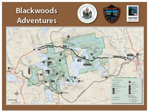
 Black Woods Scenic Byway Brochure: This two page brochure suggests places to visit on your trip along the byway. We're adding new trail heads, boat launches and other facilties to get you onto our mountains and lakes. The backside features six "geocache" locations on the byway and nearby trails. These signs will be tucked away along the byway. Grab your GPS, put on your hiking shoes and bring your canoe.
View Black Woods Scenic Byway in a larger map
 |
 |
|---|---|
Black Woods Adventure Map |
|
 |
 |
 |
|
| Ice Age Trail has a new IPad App Take a geological tour... |

Three-Dimensional View of the Blackwoods Region

Descending Tunk Mountain to the Byway

For more information, contact:
Hancock County Planning Commission
395 State Street
Ellsworth, ME 04605